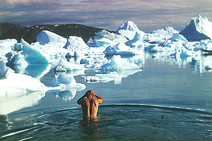
Padddling heats you up and, despite a water temperature of just six degrees Celsius, you are able to take a short bath between the chunks of ice.However, you are soon driven back to the shore by foot cramps.
Padddling heats you up and, despite a water temperature of just six degrees Celsius, you are able to take a short bath between the chunks of ice.However, you are soon driven back to the shore by foot cramps.
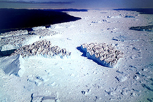
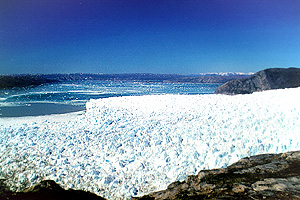
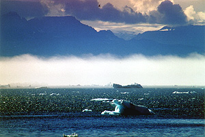
The Scandinavian Airlines "Dash 7" is getting ready to land at Ilulissat at about 22.30 p.m. It is the beginning of July and, since we are about 300 kilometers north of the polar circle, there is a glorious midnight sun, so I'm able to savour the first glimpse of the Isfjord as it appears below me. The Kangerdluaq glacier is one of the astest glaciers of the northern hemisphere, it advances about 30 meters a day. Thus, huge amounts of large and small icebergs are formed which fill the whole fjord and eventually drift into Disko Bay. From there, they slowly travel south on the ocean current. Some of these icebergs drift across the ocean for up to 20 years and reach regions as far south as New York. Even the iceberg that was rammed by the Titanic in 1912 probably originated from this bay and once started out as innocent snow on an ice sheet here.
I am picked up at the airport by Silver, an Italian, who moved here many years ago and who runs the travel agency "Tourist Nature", and he takes me to a camp site south of Ilulissat that's only meters away from the Isfjord. There, I revel in the indescribable view of Disko Bay and its many icebergs until long after midnight.
 Due to an offshore shoal, the icebergs pile up in the Isfjord until they have thawed enough in order to start their long journey.
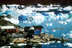
Silver and I spend the next day planning my exact route, buying food supplies and visiting the town. Ilulissat, with its approx. 4000 inhabitants the third largest town in the country, depends on fishing and, more than most other towns, tourism. But even though modern technology has entered every area of life here, the traditional ways of the Inuit are nevertheless still present everywhere. That's made most obvious by the many sled dogs that are chained up in every open space. Due to the odd stray dog here and there, I have to keep an eye on my food supplies, which I store in waterproof bags right next to my tent. Silver and I have arranged for a motorboat to take me to Ata the next day, 60 kilometers north from here. There is a small camp up there with some kayaks, one of which is reserved for me.
Stranded in the Mudderbugten - The next morning, there is dense fog. I still pack my bags early and
meet Silver for an 8 a.m. breakfast in a small cafe. Naturally, a crossing is out of the question in this weather. So we have some time and he tells me about their problems with fog. Disko Bay may be one of the sunniest and warmest places in Greenland, but as there's so much ice here, fog develops very quickly when rain-bearing air masses move in from the sea. Normally, it only stays for a short while, but a few years ago, Silver's business suffered badly when the fog didn't lift for 3 long weeks in July, the high season.
 Luckily, today the fog lifts after just two hours, so Jens, a tall, lean Inuit, and I are able to load the small boat and put to sea at noon. The visibility is excellent again, and I make myself comfortable lying down between my bags. With great skill and speed, Jens steers a zigzag course between the icebergs. Several times, seals appear in front of us and quickly disappear into the depths again. Half an hour later, we reach virtually open water. At such high speed, the boat crashes into every wave and the bags and I are thrown into the air each time, only to drop down hard an instant later. I desperately try to cling on to something. Jens, however, seems to rather enjoy the constant bouncing. After a short while, he slows down the boat, not because that might make me feel better, but because the motor is in trouble and finally sputters to a halt. It starts again after several attempts, but that only lasts for a few hundred meters and the motor soon packs up again. We take out the spark plugs to dry them, let the motor spin and put everything back together again. Without success. We repeat this game several times. Finally, we manage to get the motor to work, although it doesn't run properly and won't accept the petrol normally. We carry on at a snail's pace. Two more times the motor stops, and two more times we take everything apart and get it to work again. We are riding along the shallow coast by the time the motor goes dead for the last time, and now it won't spin anymore. Possibly due to piston seizure. We drop the little anchor and use it to pull ourselves towards the shore bit by bit for the last 200 meters. Jens tries to make radio contact with the station in Ata. Without luck.
 Today, the old, abandoned settlement of Ata serves as a base for many outdoor activities in the region, and it's the starting point of my trip.
Jens points out an antenna on a hilltop just a few kilometers away. That's where we might find the station, so we set off for it on foot. A few minutes later, we see a fisherman pass by in his motorboat in the distance. We wave our coats to attract his attention and he actually sees us and comes over. I glean from the conversation that we have completely lost our way. Ata Station is on another island, around 40 kilometers east of here. The fisherman is willing to tow our boat to the Mudderbugt, which offers more shelter. Then he takes us to the southern tip of Arve Prinsens Ejland, where Silver, who happens to be in the vicinity with a bigger boat when he receives our radio call, is going to meet us.
Around midnight, twelve hours after having started, we finally arrive at Camp Ata, the point of departure for my kayak trip. It's been an eventful day.
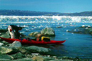
Eqip Sermia - The next morning, I'm up early in anticipation and arrange my gear on the beach. As an alternative to a Hazle Explorer (single), Silver offers me a double by Prijon, as he thinks a narrow single probably won't be big enough to accommodate all of my gear. But apart from the slightly bulky sleeping bag, which ends up in a waterproof bag at the stern, I manage to stow everything in the lockable hatches. Silver is a little concerned because nobody has been away this long with one of his boats before. Especially not on their own. So we agree that I will phone from one of the Inuit settlements. And when I have fitted out my cockpit with a GPS, a compass, a radio set and a shipping radio set, he is quite surprised that I'm so well-equipped and seems reassured.
As soon as I have heaved the kayak, which by now weighs a hefty 100 kilograms, into the water, and have taken my seat in the comfortable boat, the indescribable feeling of freedom and joyful anticipation that I often get at the beginning of a trip, slowly grows inside of me. Thanks to its weight, the narrow boat is very stable in the water, and so I am able to enjoy the sun, which is being reflected in the water, right from the start.
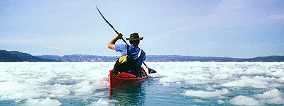 When the ice breaks off from the glacier's edge, most of it splinters into small floes. But although paddling is laborious here, it's problem-free.
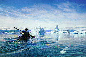
On my first day, I decide to cover the 30 kilometers to the Eqip glacier. From the outset, I come across small icebergs which drift towards me in bizarre shapes, and a few hours later, I reach the first fields of ice. To begin with, there are only scattered fragments and the odd larger floe, but they soon form a dense blanket, so that I end up having to cut a channel through the ice with my boat.
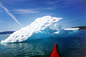
Again and again, I see areas of open water with numerous stretches of broken ice in between. I land at a large floe to get a better view. The white colossus may look like snow, but its surface turns out to be so hard and slippery that I am forced to crawl on all fours. I tie the boat to an ice screw, which I carry with me in case I need it to secure the tent in an emergency. But there is no chance of calmness during this break, as even this chunk, which measures about 20 meters, rolls alarmingly, and as a result, I only stay a few minutes and am soon on my way. Even before, I had noticed that these icebergs and chunks of ice are in constant danger of breaking up and may turn at any time. In contrast to frozen sea ice, which has an even thickness, these masses are made up of unevenly formed ice, of which only a seventh is visible. The ice slowly thaws above as well as below the water, and the centre of gravity shifts with time until the iceberg tips over. Unfortunately, I'm not able to predict when this might happen.
 It's quite obvious that the ice is being carried off by a current that emerges from underneath the glacier.
Having paddled for seven hours, I reach a sandy beach east of the glacier's breakoff edge. I had originally planned to enter the sheltered lagoon, but since I'm faced with a strong current that's coming at me with the outgoing tide, I pull the boat onto the beach, which is strewn with chunks of ice. I pitch my tent above a rocky cliff among some low shrubs. From now on, every time I land, I will have to unload the boat and carry it to a safe place, where it can't be flooded
The next day, I investigate the ridge of hills that rise up as high as 600 meters right on the edge of the glacier. There, I am treated to breathtaking views across the glacier, the bay and the distant islands.
 I keep riding past bizarre-looking icebergs, which are in a constant state of change. Their old water lines are clearly visible.
Up among the steep, black rocks, a little freshwater-pool has been heated up by the sun. I gladly use it for my bath as an alternative to the North Atlantic's six degrees Celsius. I take a 6-hour hike and when I return to my camp, I realize that my presence has been noticed. Word of my arrival the day before must have spread like wildfire among the locals, for when I get back numerous members of the Nematocera tribe are waiting by my tent. Sadly, these rather small inhabitants of the region have never heard of hospitality, and I am set upon by swarms of these blood-thirsty pests. To get away from the gnats at least for a short while, I get into the boat again to test how easy it is to roll the boat. After a few attempts, I am happy. I take a quick turn in the drift ice and return to the camp.
Qeqertaq - From there, I'm heading west. In Arsivik, I come across the remains of an old settlement. An old graveyard with wooden crosses points to this region having been used in the not too distant past. Because there's hardly any soil on this island, the graves have been covered with stones of all shapes and sizes. Some distance away, I even discover an older grave with human bones. Here, large stones have been used to create a sort of barrow, with a small burial chamber inside.
 Huge icebergs, up to 30 meters high and 100 meters long, glide down the fjord without a sound. I feel very small in my little kayak, and I try not to get too close to the breakoff edges.
A few days later, I cross the Torssukatak Fjord, at the bottom of which there is a very active glacial offshoot. Here, gigantic icebergs more than 100 meters long slowly drift west. That day, an icy wind blows across the ice sheet and I keep sheltering behind these giants. I am glad that I have my paddle-mitts with me. For although it often gets as hot as 30 degrees Celsius on the rocks when it's calm, and the only thing that's stopping you from sunbathing are the gnats, this wind quickly reminds you that you are in the Arctic. The next day, I reach the settlement of Qeqertaq, which is situated at the southern tip of the island that bears the same name. The whole bay is filled with drift ice, and there is a steady traffic of local fishermen, who make their way through the ice in their little motorboats. I, myself, land about one kilometer north of the settlement because I don't want to get bothered by stray sled dogs at night. After I have pitched my tent, I go into the village, whose colourful
wooden houses are built in the Danish style, like the houses of all the towns here. I don't mind that the small supermarket that services the 100 souls who live here, is closed, as I still have plenty of supplies, and I'm planning to head for the larger village of Saqqaq in a few days. The inhabitants are very shy and hardly anyone speaks English. Finally, I manage to ask my way to the launderette, which has a telephone, and I can make a phone call to reassure Silver. Since very few tourists come to this area, the inhabitants mainly earn a living by fishing and hunting for seals. You can find a >Royal Greenland A/S< building in the port of every town here, and this place is no exception. This company is Greenland's biggest fishing concern by far, and it buys up a large part of the catch for the international market. Furthermore, there are wooden racks all over the village that are used for drying fish in the sun, although these fish are mostly fed to the sled dogs.
 This small community keeps large stores of fuel, since it is very difficult to get fuel or other goods to this remote region during the long winters.
When, a few days later, I reach the community of Saqqaq, the most western point of my journey, I'm almost out of fuel. Because I've grown tired of spending half an hour every day on collecting branches for my cooking fires among the sparse vegetation, I'm wondering how I can increase my fuel supplies for the remainder of my trip. Unfortunately, I have left my second fuel bottle behind at the starting point. Neither do I possess any suitable empty gas bottles. So when I return from my first visit to the village still racking my brain, it seems like divine intervention when I find a 1.5 litre Sigg-bottle only 30 meters from my tent. Its smell tells me that it has been used to transport petrol before. As there's no other rubbish in this bay, and I hadn't noticed the red bottle lying on the open ground before, I get the feeling that some mysterious higher power is watching over me. This coincidence is just too incredible.
I replenish my supplies for the final ten days at the local supermarket. My Autan insect repellent is slowly running out and I try a product that works on the basis of essential oils. The first experiments illustrate the Greenlanders' attachment to nature. For when you apply this neutral product, the natural balance remains undisturbed, as far as the insects are concerned. They aren't bothered by this preparation, nor does it stop them from biting. On the other hand, I notice that my body seems to have gotten more used to the pests during the last two weeks. The swellings are much smaller now and often disappear after just a few hours.
Storm at the southern tip - My route takes me back east in glorious sunshine, past Qeqertaq, and from there I travel south along the coast of Arve Prinsens Ejland. The steep rock faces in the Smallesund are covered in mussels at low tide, and I use this opportunity to jazz up my menu. At the entrance to the Langebugt, I go on a half-day excursion up the 367 meter high Arna. From this hill, which is endowed with twin peaks of similar altitudes, I savour the view across the islands near Ritenbek in the south. This former whale-hunting station was abandoned in 1960. Plenty of buildings are still standing and, together with the large cauldrons that were used to boil whale blubber to extract its oil, they are a window on the past. Today, one of the buildings is used by tourists, who go on fishing- and whale-watching tours from here. For the next few days, I keep scanning the water surface in vain for gushers and mists from the blowholes of these giants. On this island's west coast, I only come across the occasional iceberg. But in the west, they drift along the coast of Disko Island with the north wind. An unusual spectacle can be observed over the next few days. Due to the moist wind, fog forms around the ice masses and never rises above the icebergs. It's a white, flat band that stretches along the coast of Disko Island.
 Because the wind direction is favourable, the ice, and hence the fog, stay at the opposite shore for a number of days.
Several days later, I arrive at the southern tip of the island. The north wind is still blowing, and east of the island I am hit by a strong headwind. I try to stay in the shelter of the rocks, but the gusts are coming straight down the sloping cliffs. Waves up to my chest keep swamping the boat. It's great fun at first, but it soon gets tiring. After a while, I realize that a wave has swept my waterproof camera off the deck. I turn back, and a few minutes later I see it bobbing up and down on the waves in its red case. I struggle on, all the way to the last bay. After that, the coast turns into steep cliffs, and there won't be any suitable landing conditions for the final 30 kilometers. I don't fancy having to tackle 30 kilometers in one go in this weather, nor do I want to cross the 8-kilometer wide Atasund. Since I'm all right for time, I decide to wait. I pitch my tent in a little hollow and am glad that I have enough anchor cable with me. The tent flaps noisily all night in the strong wind. When I get up the next morning, I discover that two of the ropes have come loose. My first suspicion, that the pegs have gone A.W.O.L. in the wind, proves false. The ropes have been bitten through in several places. I must have put my tent in the path of a fox. Luckily, the fox didn't see through the physics of wind. He only chewed through ropes on the lee side, and so I was spared a collapsing tent in the middle of the night.
After two days, the wind lets up and I am able to cover the final kilometers in calm, sunny weather. In the iddle of the Atasund, I come upon Silver, who is on his way to Eqip Sermia with some tourists, and we arrange to meet in Ata the following evening. I arrive in Ata around noon the next day, after 23 days in the kayak, and I unload the boat, wash a few things in the nearby stream and slowly start to pack without anyone noticing.
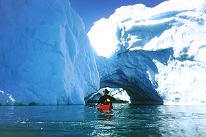 Sun and water have eaten a big cave into the iceberg. I avoid riding through the tunnel, however, because if the ice were to turn or break off, the consequences would be fatal.
Silver finally arrives around 22.00 p.m. that night. Jens takes me to his boat in a dinghy and we start out for Ilulissat at once. The wind had already shifted south at midday. At the southern tip of the island, we meet with dense fog. Since this is a clear indication of ice in the area, we slow down. After a few meters, we come across the first floes. Due to the fog, this night is uncommonly dark and we feel our way through the floes at walking speed. 15 minutes later, Silver gives the signal to retreat. At such low visibility, it would take us forever and we would constantly risk damaging the boat. We return to Ata.
The next morning, we set off early at 6 a.m. in gorgeous sunshine. The fog has already gone by the time we reach the ice. Even now, we only make slow progress. Again and again, Silver parts the floes with the boat's bow to clear the way. It seems to be quite rare for the wind to drive the ice north fromthe Isfjord. Silver says he hasn't seen this much ice in the region for 13 years.
I spend the following day going for long walks in the surroundings of Ilulissat and then, with a heavy heart after my 4 weeks here, I get on my return flight to Germany.