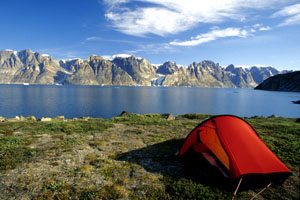
 At a length of 314 kilometers, the Scoresbysund is the largest fjord in the world. I intend to circumnavigate 600 kilometers of the Milne Land.
Text and Photos: Markus Ziebell
At a length of 314 kilometers, the Scoresbysund is the largest fjord in the world. I intend to circumnavigate 600 kilometers of the Milne Land.
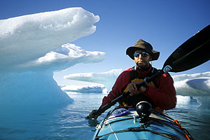
When I am dropped off full of expectation at the heliport of Ittoportomiut on the morning of July 25th after a 24 hour journey, I have more than nine months of preparation behind me. As all my attempts to find suitable travelling companions have failed, my anticipation is mixed with a certain amount of suspense. I wonder whether I am equal to the challenges ahead. But I have trained hard during the last months, and I am determined to succeed here.
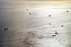
 In front of Scoresbysund, with its 500 inhabitants the second largest town in East Greenland, lies a dense ice belt. The east wind often pushes ice from the Atlantic into the fjord, which blocks shipping.
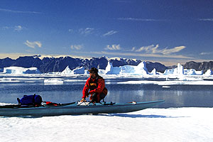
During the approach, I can already see that the entire bay is covered by thick drift ice. Just before leaving Germany, I had received an email from Karina, who works for the local "Nanu - Travel", that ice conditions are difficult at present. Once here, though, I am given hope that this may change at any moment. And sure enough, by next morning the ice has opened up a bit. So I pack my gear early, take the 7 - shot pumpgun in case of polar bears, and pick up my boat from the port authorities. My sea - kayak already started its journey 6 weeks ahead of me, on a Royal Arctic Line cargo ship at Aarlborg. Finally, everything is ready, and I embark on the first leg, making my way through the maze of ice floes. Because of my low sitting position, it is hard for me to see which channels go on and which ones end in a dead end after a few meters. Again and again, I get out of the boat when possible and up onto the ice floes, and that's how I first get acquainted with pack ice and all its obvious faults. After only a few hours, I pitch my camp just before the small settlement of Kap Hope. While I'm eating, a family of hunters joins me on my rocky coast. Hidden behind a stone rampart, they lie in wait for seals, which rest on floes here. For most of East Greenland's inhabitants, hunting for seals, musk oxen and whales still constitutes a large part of their living. Even though the Inuit wear mostly modern clothing today, the kill is still fully utilized in the traditional way. It only takes about an hour before a loud bang tears the silence, and father and son rush to recover a fully grown ringed seal by boat. Thus, this family now has enough meat for a few days. I, however, stick to my spaghetti for the next few weeks, which I enrich with a little ready - made Pemmikan. For even without seal blubber I need about 4.000 calories a day.
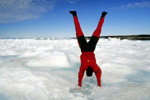 When on day three the sun finally comes out , I'm in high spirits. I am right on schedule and feel totally fit.
After crossing the Hurry Fjord, the ice becomes more open and consequently, my daily performance increases. To realize my plan to circumnavigate the Milne Land I need to paddle about 23 kilometers a day. That sounds quite easy-going. But bearing in mind all the things that might happen on a 600 kilometer trip, my ideal daily target is 30 kilometers, just to be on the safe side. On the third day, I finally tackle the planned fjord crossing south towards the Volquards - Boons - Kyst. That morning, almost 40 kilometers still separate me from the impressive mountain range in the south. Numerous glaciers plunge down the steep slopes directly into the sea. Because of the clear air and this tremendous, 2.000 meter high wall, the coast seems within my grasp after the shortest time. But it still takes hours before I reach the first ice fields that herald the coast.
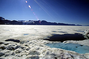 A closed ice sheet that stretches to the horizon bars my way. Too thin for walking on, and much too thick for paddling through.
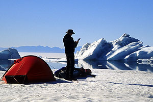 The ice fields grow ever denser, and about 6 kilometers from the coastline I run into an uninterrupted flat layer of sea ice. I get a better view from a higher ice ridge, and discover that the coast is inaccessible. I search the horizon for a way west. Without success ! The barometer promises stable weather conditions, so I decide to pitch my camp on a 30 meter long floe that appears strong enough.
I am aware of the fact that this very area is the habitat of the polar bear. I spend a predictably uneasy night, with one ear permanently at the wall of the tent, and one hand on the loaded gun. I don't hear from the King of the Arctic that night, but I am treated to a loud creaking and bubbling when a small iceberg turns in close proximity to my floe. In the morning, I'm relieved that the floe hasn't been moved by the current, or been surrounded by pack ice, but I discover that a strip approx. 5 meters wide has broken off. At this point, I remember the stories by Fritdjof Nansen, who spent weeks sitting on ice floes that kept breaking underneath his feet. After breakfast, it takes me hours to move along the edge of the ice hand over hand, and I try to follow countless channels towards the west, only to find out that there is no getting through. As I discover later, the closed sheet of ice stretches northward for about 50 kilometers, to a latitude north of Kap Leslie. Around noon, I notice that a weather front is approaching from the south. Since I don't fancy spending another night on the ice, I head back towards Jameson Land. A few hours later, the first slight gusts of wind start blowing across the water, pushing me on from behind. Today, I only reach a suitable beach after 13 hours in the kayak. The next morning, my body is still so tense from the frustrations and 60 kilometers of the previous day, that I take a break for a day.
As my original plan turned out not to be feasable, I now try to circumnavigate the island from the opposite direction, in the hope that the ice fields have dissolved in the past two and a half weeks. Having arranged with Nanu - Travel to bring a part of my provisions to Bear Island by ship, I contact Karina by satellite phone, who confirms that a ship will be there in 3 days. So the next day I head north.
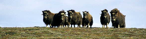
Musk oxen, who are only as tall as ponies, form a defensive circle to protect themselves from attackers.
In the afternoon, I come across a herd of musk oxen on a hill, I can already see them from quite a distance. I land and slowly sneak up on them, armed with a tripod and a gun. The musk oxen have two different defense strategies. In case of danger, they either form a circle to fend off enemies with their horns, or they simply run them over. As I don't want to fall victim to the second technique, I keep a rocky stream between myself and the herd. The animals are watching me a little warily, but they don't seem particularly worried. But when I later make the gun safe back at the boat, they are startled by the metallic click and take off at a wild gallop.
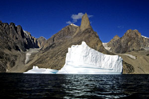
 The dense Iceberg Alley lies between me and the Milne Land in the background. On my way to Bear Island, I have to cross this maze of ice giants. Due to the narrow gaps, there is an increased risk of ice breakoff
It's a sunny, windless day, and the continuation of my journey is accompanied by the constant creaking of the icebergs, which drift close to the coast in large numbers. This makes me a little nervous, because the next day I'm facing another fjord crossing, where I'm going to have to find a passage through the maze of icebergs. That evening, I sit at the beach for a long time, and watch the endless ice breakoffs that constantly crash down the icebergs and set off steep tidal waves. The next day starts with a cloudy sky and drizzle. Due to the low temperatures, there is little movement in the ice today, so I am able to cross Iceberg Alley without problems. After a few kilometers, I reach open water and set course straight for Bear Island, which is 45 km away. As the mountain slopes are much steeper here, I intend to land at a bay with a hut indicated on my map. I'm hoping to find good landing conditions and drinking water there. Just before the bay, I pass another huge iceberg that appears quite brittle even from a distance. I have just pulled the boat onto the protruding rocks of the sheltered bay and unloaded the first two bags, when I am startled by a loud cracking sound. I watch as 800 m
away from me a broad wall of ice plunges down the iceberg into the depths. A tall, breaking wave develops in front of the iceberg, and quickly turns into a flat swell that approaches fast. I have barely a minute to prepare for it. I can't pull the boat higher onto the rocks because of its weight. So I just stand next to the boat in my drysuit with the tow rope in my hand and wait. The first wave is still slowed down by the protruding rocks. But the next four breakers crash over them, and I stand in the surf up to my hips while the boat is being thrown from left to right against the rocks. I am lucky, and my sturdy PE- boat doesn't get damaged.
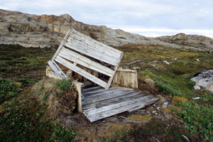 The hut indicated on the map hasn't offered any shelter for a long time. These traditional turf houses deliberately only measure a few square meters, so that they can be heated in winter.
But there is no sign of the promised hut. I go on an extensive hike and discover the remains of a small turf house. In a deep valley, I finally hear the low gurgle of a brook in between huge boulders. At least my fresh water supply is guaranteed for today. The next day, I carry on to Jytte Hawn, as that's where I'm supposed to meet with Nanu - Travel. Unfortunately, the expected ship arrives neither today nor the day after.
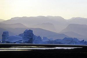
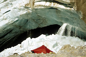
 The Øfjord, too, sees many ice giants drift in with the east wind. Numerous glacial offshoots spill over the high mountains into the valley.
I hear that the MS Nanu has run into engine trouble. A replacement ship is supposed to arrive 3 days later. Unfortunately, I can't do without this baggage, as I'm missing a week's food supply. At this point, it's clear to me that I won't be able to complete the planned circumnavigation. I've already lost too much time. I would now lack the reserves to cope with the unsure ice conditions. To make use of this enforced waiting period, I take a trip to the Ofjord. It is situated north of the Milne Land, and it is bordered on both sides by steep, approx. 2.000 meter high mountains from which plunge numerous glaciers. A light tailwind carries me past ice giants that glisten and shimmer blue in the sun. Because most of the rock faces rise vertically from the sea, there are very few possibilities to land here.
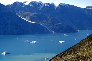
 West of the Grundvikskirken peak, I come across the broad, flat back of a lateral moraine. There are several even areas that look like they've been deposited there, and that are excellent camping sites. From here, around 50 meters above the fjord, I have a wonderful view across the fjord and the glaciers that roll down from the Milne Land on the other side.
 The next day, I visit one of the gigantic glacial offshoots, that, sadly, has already shrunk due to global warming and moved away from the coast by a few hundred meters. I have herewith reached the most westerly point of my trip, and I slowly start to head back.
In the meantime, the boat from Nanu - Travel has reached Bear Island and deposited my remaining supplies. So I set out for the north east, as I'd like to take a short excursion to the Nordwestfjord, the cradle of the icebergs. On my way there, the ice grows ever denser, so that I have to put up with long detours to find a way through. These days, I have the gun ready to hand on the foredeck at all times, so that I'm prepared should a polar bear show itself among the floes. For the first time, I notice strong tidal currents that cause rapid movements between the floes, and I have to be doubly careful not to get shut in by the ice. Thin new ice has already formed in sheltered spots between the floes. That's no wonder, since the water temperature stays around freezing point the whole year round.
 East of Bear Island, I find myself in dense ice fields yet again. Because of tidal currents, the floes are in constant motion, and I am often indanger of getting stuck between floes.
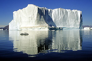
 Unfortunately, I don't possess any detailed maps of the Nordvestfjord, and I therefore have to forget about an excursion there. So I content myself with an all - day hike up Phytagoras Mountain. At a height of almost 900 meters, I can view the gigantic icebergs from above. On account of their relative proximity to the glacier's breakoff edge, the icebergs here are still young and active, and you constantly hear loud bangs as stress cracks appear in the ice.
From up here, my eye travels south, where my way leads through a great build - up of icebergs. This is where Iceberg Alley begins, which starts at the Sydkap, and approaches the coast of Jameson Land in a slight curve. The next day, I set off early, since the likelihood of ice breakoffs increases by the hour as temperatures rise throughout the day. It's windless, and the sky is clear, and I am soon surrounded by a threatening sounding column of ice giants. Because of the small gaps between these white giants that reach heights of 40 meters here, I'm often less than 50 meters away from them. In case of a sudden breakoff, I can expect dangerous tidal waves. But I am lucky, and I witness breakoffs and turns only from a safe distance today. I am relieved when I leave the last belt of icebergs behind in the afternoon and reach the beach of Jameson Land. Due to a fairly wide strip of flat beaches and shallow waters, you only come across smaller chunks of ice and floes here.

 There is radiant sunshine when I make my way through the icebergs that morning. Consequently, loud stress cracks and occasional breakoffs can be heard more frequently. But fortunately, nothing happens close to me, so I am spared the tidal waves.
 Here, the bigger floes turn into a fairytale labyrinth, and I zigzag along their channels for the next
Due to the extreme conditions, my equipment starts to show the strain after just 3 weeks. The strong ultraviolet radiation in the Arctic has made the rubber seals on my new drysuit extremely porous, even though they've been covered. So I end up with a deep tear in my collar seal when I take off my suit one night. Thankfully, I always carry spares with me, in case something needs to be repaired, and I am able to deal with this mishap the same night. Capsizing could otherwise quickly spell disaster in water temperatures around freezing point.
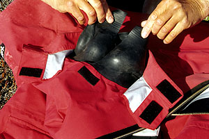 Without spare parts the damaged drysuit could have spelt disaster. A water temperature of around zero degrees Celsius rapidly leads to hypothermia and death
The closer I get to the open coast, the more strongly I feel the swell. A belt made up of small floes has formed in many areas along the beach, and it is stirred incessantly by the surf. In the fjord's estuary, the masses of pack ice that used to keep a check on the swell at the beginning of my journey are now gone. The wind, too, has increased a little during the last few days. When I turn into the Hurry Fjord, a south wind of about six Beaufort keeps driving me into the slipstream of the small icebergs for shelter. I find a sheltered beach on the east coast, and watch a flock of ptarmigan in their summer plumage only a few meters from my tent.
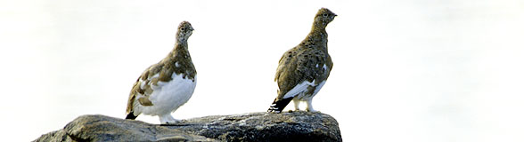
I find a shelterd beach on the east coast, and watch a flock of ptarmigan in their summer plumage only a few meters from my tent.
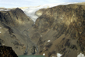 I have already seen the glacier that crowns the Roscoe Bjerge from afar, and I set out for it the next day. I brave countless ranges of scree hills before I stand, six hours later, at the edge of an 800 meter deep abyss and look down on several glacial lakes that have formed in its gorge. In the distant south, I can already make out the town of Scoresbysund.
Two days later, I turn into the small, familiar and now ice free bay of the town. The final paddle strokes just before I land my boat make me feel a little wistful. Civilization has me back ! Now I must dry my gear as best I can, and get it ready for the return journey.
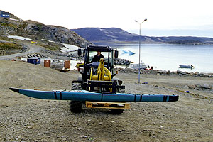 I stow most of my stuff in the boat, and the next day I check it in with the port authorities for the return transport by ship. After I have paid approx. 120 Euros at the post office, a fork - lift truck disappears into the storeshed of the supermarket with my kayak.
My arrival in Scoresbysund seems almost like a homecoming to me. Although I have only spent a day here at the beginning of my journey, most of the inhabitants seem to know me. I am greeted warmly everywhere I go, and people ask about my trip and even invite me for coffee and cake. Even the children don't show any of the timidity that I've experienced almost everywhere else in West Greenland so far. They come up to me with their broken English, and ask for my name and where I come from.
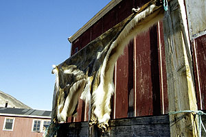 While I've been away on my trip, five polar bears appeared in town with the ice. One of them had to be shot. The pelt is drying on a rack between the houses. So the threat of polar bears is very real indeed.
I find out a lot of details about life in this community. While I've been away, five polar bears in all have been sighted in town. One of the bears had to be shot because it attacked the sled dogs. On one of my walks I see its pelt drying in the sun. For a time, there was so much drift ice in the bay that the cruise ships were unable to call at the port for 2 weeks, and as a result the tour operator suffered heavy losses. The evening before my return, all the hunters went out together and killed nine narwhales, which have been dismembered in a neighbouring bay and been distributed amongst all the inhabitants. Even the two Inuit who are staying at the guesthouse with me have profited. This is how we come to dine on Mattak that night, the blubber of the narwhale, which is cut into bite -.sized
pieces and eaten raw with a spicy sauce. As the consistency of the skin can be compared with a 2 centimeter thick rubber mat, this is a serious challenge for the neglected jaws of the West European. We end our evening together with a glass of whisky and enjoy one of the first glowing sunsets of early fall.
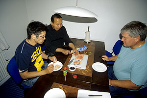 On the last evening we dine on Mattak, the raw skin of the narwhale. It's an acquired taste but full of vitamins.
 Both the summer and my journey draw to a close, and the next morning I enjoy a last look from the plane across the sea and the icebergs that have been "home" to me for a short while.